Atlas of Greece
General maps
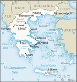 | Map of Greece |
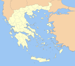
 | Topographic map of Greece |
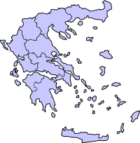 |
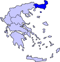
English: Modern regions of Greece
|
 |
Ελληνικά: Περιφέριες της Ελλάδας
English: Modern regions of Greece
|
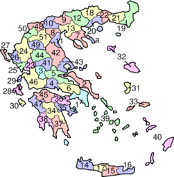 |
English: Prefectures of Greece
|
 |
Ελληνικά: Νομοί της Ελλάδας
English: Prefectures of Greece
|
History maps
This section holds a short summary of the history of the area of present-day Greece, illustrated with maps, including historical maps of former countries and empires that included present-day Greece.
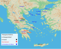 | Map of Pelasgians |
 | Dialect map of Prehistoric Greece |
 | Mycenaean remains in Epirus |
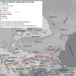 | Tribes in Thrace |
 | Map of Thracian Tribes |
 | Celtic migrations |
 | Ancient Thrace |
 | ancient Thrace,map made in 1585 |
 | Map of Orpheus's life |
 | The life of Orpheus (svg, translatable) |
 | Ancient Greece, southern regions |
 | Ancient Greece, northern regions |
 | Ancient regions of the Peloponnese |
 | Ancient Greek dialects (following Woodard 2008) |
 | Ancient Greek dialects (following Horrocks 2006) |
This file has annotations. Move the mouse pointer over the image to see them.
| (svg) Ancient Epirus |
 | Epirus in relation to Modern states Epirus |
 | (svg) Epirus in relation to Modern states Epirus |
 | Kingdom of Macedon |
 | Kingdom of Macedon |
 | Ancient Greece, Northern part |
 | Religious Sanctuaries of the Ancient Greeks |
 | Homeric Greece (around 8th century BCE) |
 | Greek colonization 8th until 6th century BCE |
 | Ancient Greece 700-600 BC |
 | Ancient Greek world around 550 BC |
 | Peloponneses |
 | Sparta in the classical age |
 | The Region in the 9th to 7th centuries BC |
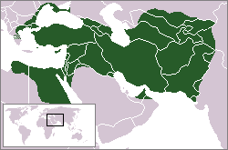 | Greece and the Persian Achaemenid Empire |
 | Greece and the Persian Achaemenid Empire |
 | Greece and the Persian Achaemenid Empire |
 | Hellenic Battles,700-168 BC [svg] |
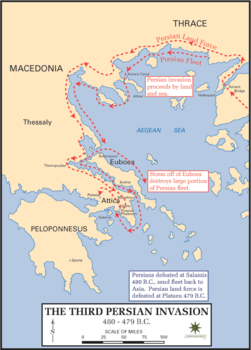 | Third Persian Invasion around 480 BC |
 | Athens and her allies in 431 BC. The city-states in the Aegean were part of the Delian League |
 | 371 BC - 362 BC, Theban Hegemony |
 | Greece 371-362 BCE |
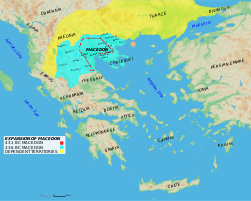 | Expansion of Macedon |
 |
English: The expansion of Macedon
|
 | Expansion of Macedon |
 | Map of the Empire of Alexander |
 | Map of the Empire of Alexander 334-323 BCE |
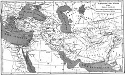 | Map of the Empire of Alexander (Norwegian) |
 | Pyrrhus' invasion of Italy |
 | Hellenistic world in 200 BCE |
 | Hellenistic period (around 200 BC) |
 | Territorial development of the Roman Empire 264 BC-192, including the conquest of present |
 | Roman conquest of Minor Asia |
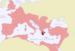
 | The extent of the Roman Republic and Roman Empire;
133 BC
44 BC (late Republic, after conquests by republican generals)
AD 14 (death of Augustus)
117 (maximum extension)
|
 | Camps of the Roman Legions in 80 |
 | Achaea in the Roman Empire (116) |
 | Epirus in the Roman Empire (116) |
 | Macedonia in the Roman Empire (116) |
 | The division of the Empire after the death of Theodosius I, ca.395 AD superimposed on modern borders.
|
 | Invasions of the Roman Empire 100-500 |
 | Division of the Roman Empire in 406 |
 | Eastern Roman Empire |
 | Eastern Roman Empire under emperor Justinianus |
 | Eastern Roman Empire under emperor Justinianus |
 | Map of the changes in borders of the Byzantine Empire |
 | The Byzantine Empire at the accession of Leo III, c. 717 |
 | The Byzantine Empire at the accession of Basil I, c. 867 |
 | The Byzantine Empire under Basil II, c. 1025 |
 | Byzantine Empire 1025 |
 | Map of the Byzantine Empire under Manuel Komnenos, c.1170. |
 | Byzantine Empire 1180 |
 | Map to show the partition of the empire following the Fourth Crusade, c.1204. |
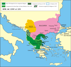 | The despotate of Epirus from 1230 to 1251 |
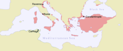
 | The Byzantine Empire in 1265 (William R. Shepherd, Historical Atlas, 1911). |
 | Byzantine Empire in 1265 |
 | The despotate of Epirus from 1252 to 1315 |
 | The despotate of Epirus from 1315 to 1358 |
 | Byzantine Empire in 1355 |
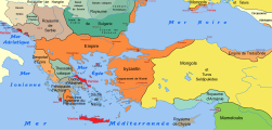
 | Map of the Serbian Empire in 1360 with territories ruled by local rulers in present-day northern Greece |
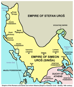 | Empire of the Romans (Greeks) and Serbs and whole Albania (Empire of Simeon Uroš - Siniša), 14th century |
 | Byzantine Empire 1400 |
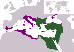
 | Growth of the Ottoman Empire |
 | Development of the European part of the Ottoman Empire |
 | Growth of the Ottoman Empire |
 | Location of the Ottoman Empire in 1683 |
 | Territorial development |
 | Graecia Vetus 1752 |
 | old Map of Ancient Greece 1809 |
 | old Map of Ancient Greece 1814 |
 | Terriorial expansion 1832-1947 |
 | Balkans after 1856 |
 | Greece in 1879 |
 | Front in World War I |
 | Front in World War I |
 | German invasion of Greece in World War II |
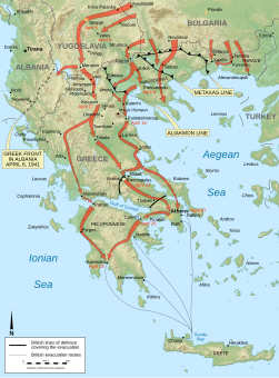
 | Front in April 1941 |
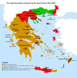 | Occupation zones during World War II |
Ethnic and linguistic maps
 | Ethnographic map of Greece (1847) |
 | Ethnographic map of Greece (1861) |
 | Ethnographic map of Greece (1877) |
 | Ethnographic map of Greece (1877) |
 | Ethnographic map of Greece (1880) |
 | Ethnic map of Greece (1890) |
 | Ethnic map of Pelopones (1890) |
 | Ethnic map of Greece (1897) |
 | Ethnic map of Greece (late 19th century) |
| [[|border|251x400px]] | Ethno-linguistic map of Greece (1912) |
 | Ethnographic map of Thrace (1912) |
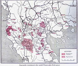 | Romance languages in Greece (1930) |
 | Modern Greek dialects |
 | Ethno-linguistic minorities in Greece |
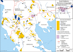 | Romance languages in Greece |
Regional maps
Macedonia - modern maps
Macedonia - historical maps
 | Borders of Region of Macedonia according to different authors (1843-1927) |
| Ethnograhic map of European Turkey and its vassal states, 1861 |
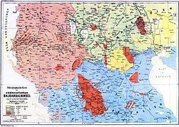
| Ethnic map of the Southwestern Balkan Peninsula (1890) |
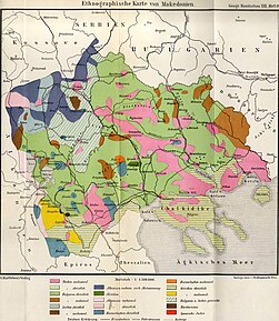 | Ethnographic map of Macedonia, 1892 |
| The peoples of the Balkan Peninsula (1897) |
 | Bulgarian Ethnographic map of the modern Macedonia region, 19th century |
 | Serbian Ethnographic map of the modern Macedonia region, 19th century |
 | Division of Macedonia region between the Balkan states, 1913 |
Thrace
 | Thrace |
 | Thrace |
| [[|border|251x400px]] | Thrace |
 | Thrace |
Crete
 | Crete |
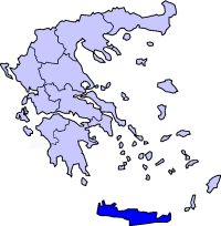 | Crete |
 | Crete |
 | Crete |
Ionian Islands
Old maps
 | Map of Greece in 1834 |
 | Ethnographic map of the Epirus region, 1878. Greek point of view |
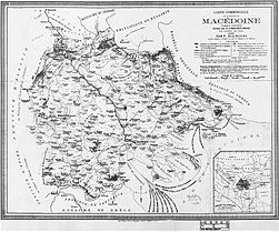 | The wider geographical Macedonia region, 1885 |


.svg)


.svg)

.svg)
.png)

.svg)


.svg)

_en.svg)


.svg)
.svg)


.svg)
.jpg)
_(English).svg)
_(English).svg)


.svg)


.svg)
_no_region_markers.svg)
.svg)


.jpg)


_(English).jpg)


.PNG)


.PNG)


.jpg)
.jpg)


.png)
.jpg)


No hay comentarios:
Publicar un comentario