Atlas of Iran
|
 |
Iran
|
|
|
|
|
| ايران |
|
|
| فارسی | [1]ايران - جمهوری اسلامی ايران
ایران کشوری در جنوب غربی آسیا در منطقهٔ مشهور به خاورمیانه است. پایتخت آن تهران است.
|
| Azərbaycan | İran Qərbi-Asiyada dövlət. Şimalda Ermənistan, Azərbaycan və Türkmənistanla , şərqdə Əfqanıstan və Pakistanla, qərbdə İraq və Türkiyə ilə sərhəddir. Şimaldan Xəzər dənizi ilə, Cənubdan İran və Oman körfəzləri ilə əhatə olunmuşdur. Ərazi 31 ostana bölünmüşdür. Ostanlara rəhbərliyi Daxili İşlər naziri tərəfindən təyin edilən general-qubernatorlar edir. Ostanlar öz növbələrində şəhristanlara bölünürlər. Şəhristanların tərkibinə şəhərlər və digər ərazilər daxildirlər. Şəhristana rəhbərlik edən məmurlar bəzən təyin olunur bəzəndə seçilirlər. |
| Kurdî / كوردی | Îran (farsî: جمهوری اسلامی ایران) welatekê Rojhilata Navîn e. Navê wê yê fermî Komara Îslamî ya Îranê ye (bi Farisî: Comhûrîyê Êslamîyê Îran). Îran li Bukur bi Ermenistanê, Azerbaycanê û Tirkmenistanê re, li rojava bi Tirkiye û Îraqê re, li rojhilat bi Efxanistan û Pakistanê re û li başûr bi Kendava Farisî û Kendava Omanê re û li aliyê din ê wan herduyan re bi Kuweyt , Erebistana Siûdî, Bahreyn, Qeter, Mîrnişînên Erebî yên Yekbûyî û Ommanê re hevsî e. Mezzhebê fermî yê Îranê Şî û zimanê fermî jî Farisî ye. |
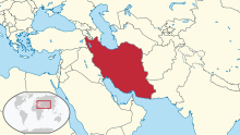
| English | Iran - Islamic Republic of Iran
The Islamic Republic of Iran, formerly known as Persia in the West, is a large Western Asian country located in the Middle East and Central Asia. Its area equals the size of the United Kingdom, France, Spain, and Germany combined. Iran borders ► Armenia, ► Azerbaijan (including its ► Nakhichevan exclave) and ► Turkmenistan to the north, ► Afghanistan and ► Pakistan to the east, and ► Iraq (with ► Kurdistan) and ► Turkey to the west. In addition, it borders the Persian Gulf, across which lie ► Kuwait, ► Iraq, ► Saudi Arabia, ► Bahrain, ► Oman, ► Qatar, and the ► United Arab Emirates. |
|
|
| Short name | Iran |
| Official name | Islamic Republic of Iran |
| Status | Independent country, united since 1502 |
| Location | Middle East |
| Capital | تهران (Tehran) |
| Population | 75,149,669 inhabitants |
| Area | 1,628,771 km² |
| Major languages | Persian (official), Azerbaijani, Kurdish |
| Major religions | Shi'a Islam |
| More information | Iran, Geography of Iran, History of Iran and Politics of Iran |
| More images | Iran - Iran (Category). |
|
General maps
 | Map of Iran |
 | Map of Iran in Persian |
 | Map of Iran |
 | Topographic map |
History maps
This section holds a short summary of the history of the area of present-day Iran (Persia), illustrated with maps, including historical maps of former countries and empires that included present-day Iran (Persia).
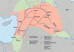 | Deportation of the Jews by the Assyrian Empire |
 | Median Empire |
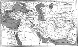
Persian Empire
 | The Persian Achaemenid Empire (not at its greatest extent) |
 | The Persian Achaemenid Empire (at its greatest extent) |
 | The Persian Achaemenid Empire (not at its greatest extent) |
Macedonian Empire
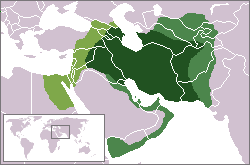
 | Map of the Empire of Alexander |
 | Map of the Empire of Alexander 334-323 BCE |
 | Map of the Empire of Alexander (Norwegian) |
 | Map of the diadochs kingdoms (in french) |
 | Hellenistic world in 200 BCE |
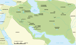
Parthia
 | 250 BCE-225 CE: Parthia (اشکانیان - Ashkâniân) - independent monarchy
|
 | The Parthian empire |
 | Map of Parthia 100 BC |
 | Indo-Sassanide Empire |
 | The Persian Sassanian Empire (226-650) in 602 to 629, Strokes: Under Sassanid military control. |
 | Sassanide Empire |
 | Sassanide Empire |
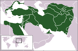
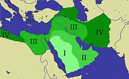 | Expansion of the Caliphate: I: Muhammad; II: Abu Bakr; III: Omar and IV: Othman |
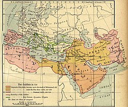 | Caliphate around 750 |
 | Iran around 1000 |
This file has annotations. Move the mouse pointer over the image to see them.
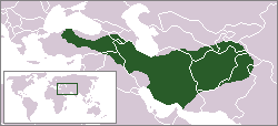
| Map showing changes in borders of the Mongol Empire from founding by Genghis Khan in 1206, Genghis Khan's death in 1227 to the rule of Kublai Khan (1260–1294). (Uses modern day borders)
Mongol Empire
By 1294 the empire had split into:
|
 | The Safavid Empire |
 | Iran around 1900 |
 | Kurdish Republic of Mahabad and Autonomous Republic of Azerbaijan in 1945-1946 |
Old maps
This section holds copies of original general maps more than 70 years old.
 | Map of Persia around 1700 |
 | A 1753 map by Robert De Vaugondy titled ESTATS DU GRAND-SEIGNEUR EN ASIE where the color yellow marks the Greater Persian territores. |
 | An 1808 British map of Persia. |
Ethno-linguistic maps
| [[|border|251x400px]] | Ethnic Map of Iran |
 | The Iranian languages |
Other maps
 | International trade |
 | Major crops |
 | Oil |
 | Nuclear program |
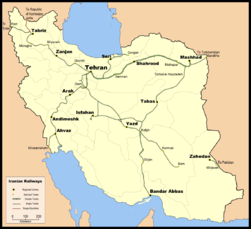 | Railways |
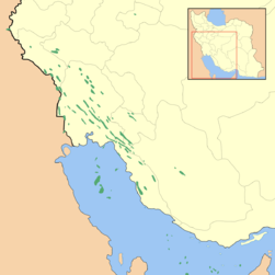
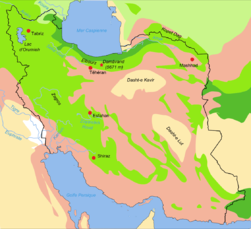
 | Biotopes of Iran |
 | Biotopes of Iran |
Satellite maps
 | Satellite map |


.jpg)


.GIF)


No hay comentarios:
Publicar un comentario