Atlas of Iraq
 |
Iraq
|

|
|
|
|
| العراق
عيَراق |
|
|
| العربية | [1]العراق - جمهورية العراق
العراق هو احدى الدول العربية الواقعة في المشرق العربي، يقع في جنوب غرب القارة الآسيوية. يقع إلى الشمال من المملكة العربية السعودية، وإلى الجنوب من تركيا، والشرق من سورية و الأردن ، وإلى الغرب من ايران. هناك آراء مختلفة عن اصل كلمة العراق حيث يرجح بعض المستشرقين ان مصدرها هي مدينة أورك السومرية القديمة والتي تسمى الأن بالوركاء وقد ذكرت مدينة أورك في ملحمة گلگامش حيث قام گلگامش ببناء سور حول المدينة و معبد للآلهة عشتار ، يرى البعض الأخر ان العراق مصدرها العروق نسبة الى النهرين دجلة و الفرات اللتين ولاهميتيهما شبهتا بالعرق او الوريد ويرى البعض الأخر انها سميت بالعراق نسبة إلى عروق اشجار النخيل التي تتواجد بكثرة في جنوب و وسط العراق بينما يرى الأخرون ان اصل التسمية هي عراقة المنطقة الموغلة بالقدم
|
| كوردي | [2]عيَراق - كۆماری عێراق |
| English | Iraq - Republic of Iraq
The Republic of Iraq is a country in Southwest Asia encompassing most of Mesopotamia as well as the northwestern end of the Zagros mountain range and the eastern part of the Syrian Desert. It shares borders with ► Kuwait and ► Saudi Arabia to the south, ► Jordan to the west, ► Syria to the northwest, ► Turkey to the north, and ► Iran to the east. It has a very narrow section of coastline at Umm Qasr on the Persian Gulf. In the north ► Iraqi Kurdistan has autonomous status. |
|
|
| Short name | Iraq |
| Official name | Republic of Iraq |
| Status | Independent country since 1932 |
| Location | Middle East |
| Capital | [3] بغداد (Baghdad) |
| Population | 26,783,383 inhabitants |
| Area | 438,317 km² |
| Major languages | Arabic, Kurdish (both official), Assyrian and Turkmen |
| Major religions | Islam |
| More information | Iraq, Geography of Iraq, History of Iraq and Politics of Iraq |
| More images | Iraq - Iraq (Category). |
|
General maps
 | Map of Iraq |
 | Map of Iraq |
 | Map of Iraq |
 | Occupation zones |
| [[|border|251x400px]] | 1980 Tourist Map |
Maps of Iraqi Kurdistan
 | Location of Iraqi Kurdistan |
 | Kurdish-speaking area of Iraq |
History maps
This section holds a short summary of the history of the area of present-day Iraq, illustrated with maps, including historical maps of former countries and empires that included present-day Iraq.
 | Akkadian Empire |
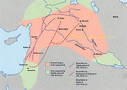 | Deportation of the Jews by the Assyrian Empire |
 | Median Empire |
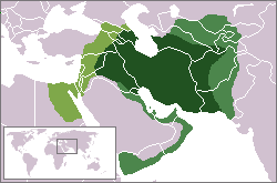
 | The Persian Achaemenid Empire |
 | The Persian Achaemenid Empire |
 | The Persian Achaemenid Empire |
 | Map of the Empire of Alexander |
 | Map of the Empire of Alexander 334-323 BCE |
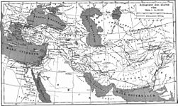 | Map of the Empire of Alexander (Norwegian) |
 | Hellenistic world in 200 BCE |
 | Map of Parthia 100 BC |
 | Territorial development of the Roman Empire 264 BC-192, including the conquest of present |
 | Roman conquest of Minor Asia |
 | The extent of the Roman Republic and Roman Empire;
133 BC
44 BC (late Republic, after conquests by republican generals)
AD 14 (death of Augustus)
117 (maximum extension)
|
 | Camps of the Roman Legions in 80 |
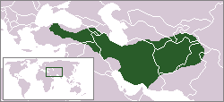
 | Indo-Sassanide Empire |
 | The Persian Sassanian Empire (226-650) in 602 to 629, Strokes: Under Sassanid military control. |
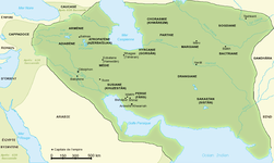 | Sassanide Empire |
 | Sassanide Empire |
 | Sassanide Empire |
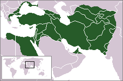
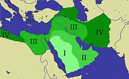 | Expansion of the Caliphate: I: Muhammad; II: Abu Bakr; III: Omar and IV: Othman |
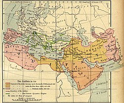 | Caliphate around 750 |
 | The region around 1000 |
This file has annotations. Move the mouse pointer over the image to see them.
| Map showing changes in borders of the Mongol Empire from founding by Genghis Khan in 1206, Genghis Khan's death in 1227 to the rule of Kublai Khan (1260–1294). (Uses modern day borders)
Mongol Empire
By 1294 the empire had split into:
|
 | The Safavid Empire |
 | Growth of the Ottoman Empire |
 | Growth of the Ottoman Empire |
 | Location of the Ottoman Empire in 1683 |
 | No Fly Zones |
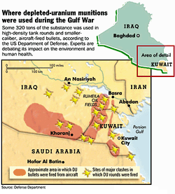 | Approximate area and major clashes in which DU rounds were used |
 | Iraqi War 2003 |
Other maps
 | Ethnic map of Iraq |
Satellite maps
 | Satellite |


.png)

.svg)

.jpg)


.jpg)


.GIF)


No hay comentarios:
Publicar un comentario