Atlas of Ethiopia
|
 |
Ethiopia
|

|
|
|
|
| ኢትዮጵያ |
|
|
| አማርኛ | ኢትዮጵያ - የኢትዮጵያ ፌዴራላዊ ዲሞክራሲያዊ ሪፐብሊክ[1]
ኢትዮጵያ በኣፍሪካ ቀንድ የምትገኝ የረጅም ዘመን ታሪክ ያላት ሀገር ናት። ድሮ አቢሲኒያ በሚል መጠሪያ ትታወቅ ነበር። በአፍሪካ ነፃነታቸውን ጠብቀው ለመኖር ከቻሉ ሁለት አገሮች አንዷ ነች። የታሪክ ሊቃውንት ኢትዮጵያ የሚለው ቃል ከግሪክ መወረሱን እና ትርጕሙም "በፀሓይ የከሰለ ገጽ" ማለት እንደሆነ ይገልጻሉ። ቀደምት የኢትዮጵያ ሊቃውንት ግን ይህን አይቀበሉትም። ስያሜው የአክሱም መሥራች ከነበረው "ኢትዮጲስ" እንደተገኘ፤ እርሱም የኩሽ ልጅ፣ (የካም የልጅ-ልጅ፣ የኖህ የልጅ-ልጅ-ልጅ) እንደነበር ይተርካሉ።
|
| English | Ethiopia - Federal Democratic Republic of Ethiopia
The Federal Democratic Republic of Ethiopia is a country situated in the Horn of Africa (landlocked as of May 24, 1993). It is the third-most populous nation in Africa, bordered by ► Eritrea to the north, ► Djibouti to the northeast, ► Somalia, with ► Somaliland to the southeast, ► Kenya to the south, and ► Sudan to the west. Ethiopia is the only country in Africa with an unbroken sovereignty and is one of the oldest continuous nations in the world. Recently regarded as "the cradle of mankind", Ethiopia is also the second-oldest official Christian nation in the world, after Armenia. It has long been an intersection between the civilizations of North Africa, the Middle East and the rest of Africa. Unique among African countries, Ethiopia was never colonised, maintaining its sovereignty throughout the Scramble for Africa. |
|
|
| Short name | Ethiopia |
| Official name | Federal Democratic Republic of Ethiopia |
| Status | Independent country, statehood since 980 BCE |
| Location | North-East Africa |
| Capital | አዲስ አበባ[2] (Addis Ababa) |
| Population | 85,000,000 inhabitants |
| Area | 1,104,300 km² |
| Languages | Amharic, (official), regional languages, like Oromifa and Tigrinya |
| Major religions | Coptic orthodoxy and islam |
| More information | Ethiopia, Geography of Ethiopia, History of Ethiopia and Politics of Ethiopia |
| More images | Ethiopia - Ethiopia (Category). |
|
General maps
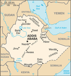 | Basic map of Ethiopia |
 | Terrain map of Ethiopia |
Maps of divisions
This section holds maps of the administrative divisions.
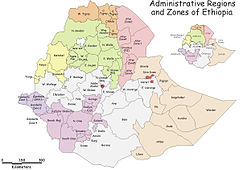 | Map of zones and regions (as of 2000; outdated) |
-
-
-
-
-
-
-
-
-
Southern Nations, Nationalities and Peoples state
-
History maps
This section holds a short summary of the history of the area of present-day Ethiopia, illustrated with maps, including historical maps of former countries and empires that included present-day Ethiopia.
 | Aksum and surrounding countries |
 | The region in 1908 |
This file has annotations. Move the mouse pointer over the image to see them.
| Ethiopia in the Italian colonial empire in 1940 |
Old maps
This section holds copies of original general maps more than 70 years old.
 | Upper Nubia and Abyssinia, 1891 |
 | Map of Egypt, Ethiopia and Sudan in 1892 |
Other maps
| These maps are from before the independence of Eritrea |
 | Economic map |
 | Ethnic map |
 | Vegetation map |
 | Languages in Ethiopia |
==Satellite maps==


No hay comentarios:
Publicar un comentario