|
 |
|
Cyprus
|

|
|
|
|
| Κύπρος
Kıbrıs |
|
|
| Ελληνικά | Κύπρος - Κυπριακή Δημοκρατία[1]
Η Κύπρος είναι νησί της ανατολικής Μεσογείου θάλασσας, το τρίτο σε μέγεθος, και βρίσκεται 100 περίπου χιλιόμετρα νότια της Τουρκίας και 120 χιλιόμετρα δυτικά της Συρίας. Γεωγραφικά η Κύπρος ανήκει στην νοτιοδυτική Ασία. Ωστόσο, επειδή ιστορικά, πολιτιστικά η Κύπρος ακολούθησε τη πορεία όλου του Ελληνισμού, μπορεί να θεωρείται μέρος της Δύσης και της Ευρώπης.
|
| Türkçe | Kıbrıs - Kıbrıs Cumhuriyeti
Kıbrıs Akdeniz'de bir adadır. Kuzeyinde 65 km mesafe ile Türkiye, doğusunda 112 km mesafe ile Suriye, 267 km ile İsrail, 162 km ile Lübnan; güneyinde 418 km ile Mısır; batısında ise 965 km ile Yunanistan yer almaktadır. Kıbrıs adası 30.33 ve 35.41 eylemleri ve 32.23 ve 34.55 boylamları arasındadır. KKTC'nin yüzölçümü 3.355 km²dir. Yaklaşık olarak ada sahillerinin yarısı KKTC sınırları içerisindedir.
|
| English | Cyprus - Republic of Cyprus
The Republic of Cyprus is a Eurasian island nation in the eastern part of the Mediterranean Sea south of the Anatolian peninsula (Asia Minor). A Turkish invasion in 1974 led to the establishment of a separatist government to govern the invaded area, currently styling itself the Turkish Republic of ► Northern Cyprus, separated from the south by the UN-controlled Green Line and recognized only by Turkey. The Republic of Cyprus has been a member state of the European Union since 1 May 2004. The British possess ► Akrotiri and Dhekelia on the island. Cyprus lies south of ► Turkey, west of ► Syria and ► Lebanon and north of ► Egypt. |
|
|
| Short name | Cyprus |
| Official name | Republic of Cyprus |
| Status | Independent country since 1960, member of the ► European Union since 2004 |
| Location | Mediterranean Sea |
| Capital | Λευκωσία[2] (Nicosia)
Lefkoşa |
| Population | 784,301 inhabitants |
| Area | 9,251 km² |
| Major languages | Greek, Turkish (both official) |
| Major religions | Cypriot Orthodoxy, Islam |
| More information | Cyprus, Geography of Cyprus, History of Cyprus and Politics of Cyprus |
| More images | Cyprus - Cyprus (Category). |
|
General maps
 | Map of Cyprus |
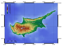 | Topographic map of Cyprus |
 | Map of municipalities of Greek-controlled area of Cyprus |
History maps
This section holds a short summary of the history of the area of present-day Cyprus, illustrated with maps, including historical maps of former countries and empires that included present-day Cyprus.
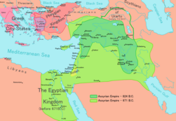 | The Region in the 9th to 7th centuries BC |
 | The Persian Achaemenid Empire |
 | The Persian Achaemenid Empire |
 | The Persian Achaemenid Empire |
 | Map of the Empire of Alexander |
 | Map of the Empire of Alexander 334-323 BCE |
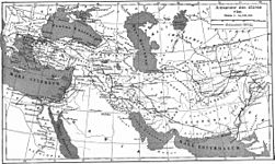 | Map of the Empire of Alexander (Norwegian) |
 | Hellenistic world in 200 BCE |
 | Territorial development of the Roman Empire 264 BC-192, including the conquest of present |
 | Roman conquest of Minor Asia |
 | The extent of the Roman Republic and Roman Empire;
133 BC
44 BC (late Republic, after conquests by republican generals)
AD 14 (death of Augustus)
117 (maximum extension)
|
 | The division of the Empire after the death of Theodosius I, ca.395 AD superimposed on modern borders.
|
 | Division of the Roman Empire in 406 |
 | Eastern Roman Empire |
 | Eastern Roman Empire under emperor Justinianus |
 | Eastern Roman Empire under emperor Justinianus |
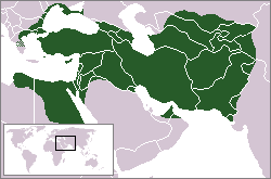
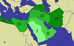 | Expansion of the Caliphate: I: Muhammad; II: Abu Bakr; III: Omar and IV: Othman |
 | Caliphate around 750 |
}}
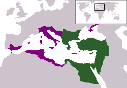
 | The Byzantine Empire under Basil II, c. 1025 |
 | Byzantine Empire 1025 |
 | Cyprus and the Crusader states in 1135 |
 | The Ayyubid Empire of Saladin around 1190 |
 | Map of the Byzantine Empire under Manuel Komnenos, c.1170. |
 | Byzantine Empire 1180 |
 | The Kingdom of Cyprus in 1265 (William R. Shepherd, Historical Atlas, 1911). |
 | Kingdom of Cyprus in 1265 |
 | Kingdom of Cyprus in 1355 |
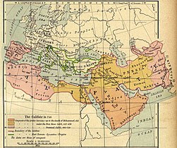
 | Location of the Ottoman Empire in 1683 |
This file has annotations. Move the mouse pointer over the image to see them.
| Cyprus inside the British Empire |
| A former British colony, the Republic of Cyprus gained independence in 1960 while the United Kingdom retained two Sovereign Base Areas. Following 11 years of alternating intercommunal violence, leading to the sending of UN peacekeeping forces in 1964, and peaceful attempts at reconciliation in response to an Athens-engineered coup aimed at uniting the island with Greece, Turkey launched a two-stage invasion of the island in 1974. The invasion led to the internal displacement of thousands of Greek and Turkish Cypriots and the subsequent establishment of a separatist regime to govern the invaded area, currently styling itself the Turkish Republic of Northern Cyprus, separated from the south by the UN-controlled Green Line and recognized only by Turkey. |
Old maps
This section holds copies of original general maps more than 70 years old.
 | Early 18th century map by Pieter van der Aa |
Satellite maps
 | Satellite map |
 | Satellite map |


.jpg)


.PNG)


.PNG)


No hay comentarios:
Publicar un comentario