|
 |
Åland
|

|
|
|
|
| Åland
Ahvenanmaa |
|
|
| Svenska | Åland - Landskapet Åland
Åland är en ögrupp i mellersta Östersjön mellan det finländska fastlandet och Sverige. Åland är ett självstyrt län i Finland men är officielt enspråkigt svenskt och har en kultur snarlik den svenska. Ålands unika politiska status gör att Åland har en egen regering och ett eget parlament med rätt att stifta egna lagar. Landskapet är dessutom en demilitariserad zon och Ålands status skyddas av internationella garantier. Ålands folkmängd är ca. 27 000, och dess endast stad är Mariehamn.
|
| Suomi | Ahvenanmaa - Ahvenanmaan maakunta
Ahvenanmaa on keskisessä Itämeressä Suomen mantereen ja Ruotsin välissä sijaitseva saariryhmä. Se on myös maakunta, jolle on erillislailla myönnetty laaja itsehallinto. Ahvenanmaan ainoa virallinen kieli on ruotsi, ja sen se on kulttuurisesti suuntautunut Ruotsiin. Maakunta on demilitarisoitu kansainvälisillä sopimuksilla. Se on aluejaossa lähinnä rinnasteinen Suomen viiteen lääniin. Sen väkiluku on noin 27 000 ja sen ainoa kaupunki on Maarianhamina.
|
| Nederlands | Åland - de autonome provincie Åland
Åland (Fins: Ahvenanmaa) is een eilandengroep in het midden van de Oostzee, gelegen tussen het vasteland van Zweden en dat van Finland. Het is een autonome provincie van Finland: Het heeft een eigen politieke status met een grote mate van autonomie en een eigen parlement. Åland is officieel gedemilitariseerd door internationale verdragen. Åland is officieel ééntalig Zweeds en cultureel heeft het meer verwantschap met Zweden dan met Finland. Het aantal inwoners bedraagt ongeveer 27.000 en de enige stad van belang is de hoofdstad Mariehamn.
|
| English | Åland - Province of Åland
Åland, also called the Åland Islands (in Finnish, Ahvenanmaa), is an archipelago at the approximate midpoint of the Baltic Sea, between continental ► Finland and ► Sweden. It is an autonomous administrative province of Finland. Its only official language is Swedish, and culturally, it leans towards Sweden. It has a unique political status within Finland, with a wide degree of autonomy and its own parliament. The province has been demilitarised by international treaties. Åland's population is approximately 27,000, and its only city is Mariehamn (in Finnish, Maarianhamina). |
|
| Short name | Åland |
| Official name | Province of Åland |
| Status | Autonomous province of ► Finland under international treaty, Finnish since 1918 |
| Capital | Mariehamn |
| Population | 27,096 inhabitants |
| Area | 13,517 km² |
| Major languages | Swedish |
| Major religions | Protestantism |
| More information | Åland, Geography of Åland, History of Åland and Politics of Åland |
| More images | Åland - Åland (Category). |
|
General maps
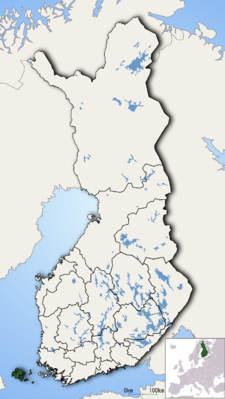 | Location of Åland in Finland
Ålands läge i Finland |
 | Map of Åland
Karta över Åland |
 | Map of Åland
Karta över Åland |
 | Borders of Åland
Ålands gräner |
History maps
This section holds a short summary of the history of the area of present-day Åland, illustrated with maps, including historical maps of former countries and empires that included present-day Åland. From 1634 the
Swedish archipelago of Åland was a part of the
province of Turku and Pori. In 1809, when Finland became part of Russia, as the Grand Duchy of Finland, Åland followed. After the independence of Finland in 1917, disputes over the ownership of the arose between Sweden and Finland. Initially Sweden occupied the islands, followed by German forces at the request of the Finnish government. Though the residents of the islands favoured cession back to Sweden, the League of Nations decided in 1921 that Finland shall retain the sovereignty over the province, though the islands shall become an autonomous territory. A year later, Finland established the autonomous region of the Åland islands.
No maps are available, though relevant maps can be found at the
Atlas of Finland and the
Atlas of Sweden.
Old maps
This section holds copies of original general maps more than 70 years old.
 | Swedish-language map of Åland
Svenskspråkig karta över Åland |
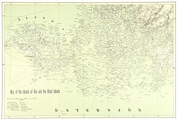 | Map of Åland and Turku (1894)
Karta över Åland och Åbo (1894) |


_MAP_OF_THE_%C3%85LAND_ISLANDS.jpg)
No hay comentarios:
Publicar un comentario